Wanaka to Manapouri
Wanaka (Click image for full screen view)
Manapouri (Click image for full screen view)
New Zealand Vacation
Monday, January 29:
Wanaka - Manapouri
Wanaka to Manapouri |
|
|
Wanaka (Click image for full screen view) |
Manapouri (Click image for full screen view) |
Went out for breakfast. I had “pancakes" more like blinis. Good, though.
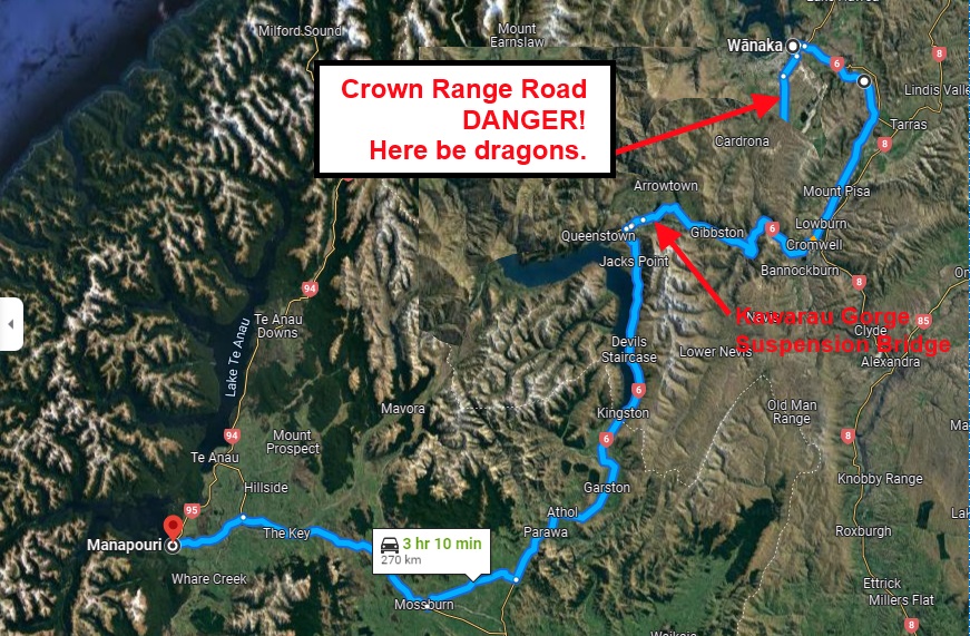
Jenny and I split up for the morning. I went to see the Fighter Pilot's Museum. I’m sort of a WW II aircraft buff, and seeing in the flesh the P-51, Spitfire, and Hurricane, which I only knew from pictures was a real treat. They also had a couple of Russian Policarpovs, strange stubby fighters with fixed landing gear and a semi-exposed radial engine. They looked like mid-war American P-26’s. I sat in front of a computer flight simulator and flew my P-47 against a bunch of inept Messerschmidt 110’s and Heinkels, and still failed to shoot any of them down. I watched a Hurricane that had been at an airshow elsewhere come in for a landing. [Note: As I enter this report today in 2022, the Fighter Pilot's Museum appears to have disappeared sometime in the past two decades. But it says that I saw a Hurricane come in for a landing, so it must have been situated somewhere near the airstrip. So that's where I put the arrow.]
While I was playing fighter ace, Jenny hiked Mt. Iron. Shortly after noon, we met up and headed south towards Manapouri and the Fiordlands. Fiordlands is a huge tract of land in the south western corner of the country protected from development and habitation. It encompasses both sides of the Southern Alps, with some of the most beautiful scenery in the country.
We looked at the map and saw a lesser road over the Crown Range of mountains that would cut a couple of miles off our journey. We got about 7 or 8 miles down that road when we ran into some signs warning us of primitive road conditions ahead and prohibiting use by rental cars. That jogged my memory, and I looked again at the rental contract. Sure enough, our insurance didn’t cover us on the Crown Range Road. False start. Here lie dragons! With tails between our legs, we resignedly turned Rosinante back the way she came and took Route 6.
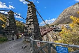
Route 6 was nothing to sneer at either. It wound through the Pisa Range and down the Kawarau Gorge. (Damn! All these Maori names are starting to run together for me. Formula: Three syllables. The first starts with a K or a W. The last ends in au or ui. It means The Place Where Someone Did Something To Something Else.) The Gorge is crossed by a high suspension bridge built in 1880, which is the oldest commercial bungee-jumping site in the world. You’ve seen the photos and the movies. Not much more to be said except it looks even crazier in real life than on the screen. (The bridge was pretty neat, though, says Mike, the engineer.)

Kawarau Gorge Suspension Bridge
(Image courtesy Google Images
The Gorge opens up at its base into serious sheep country. Looking like high plateau valleys ( except not actually all that high) between abrupt mountain ranges, it is dotted with sheep as far as the eye can see. Kingston, at the base of the Gorge is the terminus of the Kingston Flier, a lovingly restored steam train.
Manapouri is a sleepy little resort village. We ate dinner outdoors at the Beehive Cafe on main lakefront drag. [Yet another casualty of the passing years. It no longer appears on Google Maps.] Five whole minutes would elapse between passing cars. This country is empty! Walked along Frasers Beach by the lake at sunset, and retired to Possum Lodge, yet another Backpackers’ establishment. We shared it with 2 or 3 other couples who might have been poltergeists for all their interaction with us. Very strange: we each went about our own affairs, in the same living room and kitchen, but as far as each couple was concerned, the others hardly existed.
I spent the evening working on the skit script. Minor concern is cropping up. I’ve been taking notes for this monologue on a palm pilot, and the batteries are now down to about one half. I’m going to have to find a charger somewhere.